At their regular meeting on March 27, Council formally adopted the Henner Heights Outline Plan as amended, which Hoskin Planning & Development Services Inc., on behalf of Burman University, has been working on with the City of Lacombe for several years.
“The Henner Heights Outline Plan will provide future residents with a diverse range of housing choices that meet the needs of all income levels and life stages, and will ensure Lacombe is a connected, walkable community, with facilities and greenspaces that are accessible to all, “ said Mayor Steve Christie. “It will also assist the City to ensure appropriate infrastructure supported by the Off-Site Levy Bylaw is in place to sustain development in a timely and orderly fashion.”
“The Henner Heights Outline Plan has been crafted to ensure that development within the immediate vicinity of the Burman University campus is compatible with our future vision,” said Burman University President Dr. Mark Haynal. “The outline plan will assist in the phasing of development over an extended period of time without compromising the remnant lands, which will continue to be used for agriculture until they can be developed.”
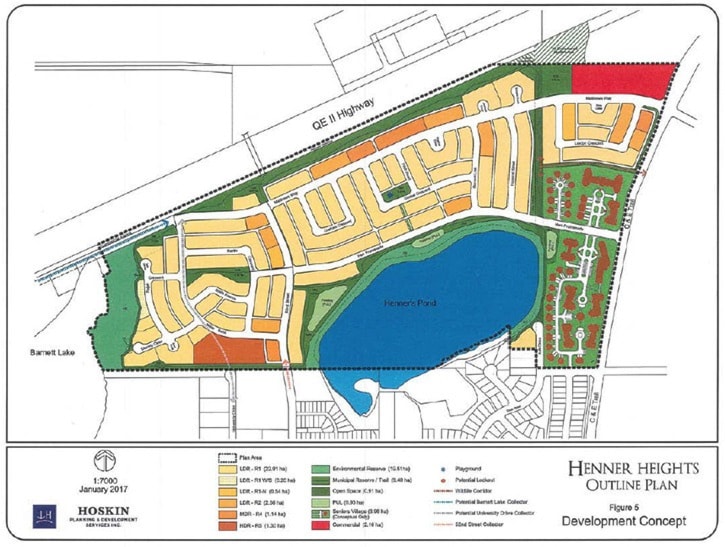
The Henner Heights Outline Plan was prepared to plan for the future development of 88 hectares (217 acres) of land in the northern area of Lacombe. The plan is bounded by C&E Trail to the east, Lake Barnett to the west, Highway 2 to the north, and Henner’s Pond to the south.
The Outline Plan establishes a detailed design and layout for the land and includes elements for development such as the full road network, trail system, location of park space, zoning and overall density calculations for the area. It envisions a predominantly residential development with access to Henner’s Pond. Strategically located commercial nodes will provide services to the residents, including those in the proposed Seniors Village.
‘‘The adoption of this plan provides guidance for future subdivision, zoning and development, and will create another wonderful neighbourhood in Lacombe,’’ said Acting Director of Planning and Operations Lyla Peter. ‘‘The plan will provide for about 1200 additional housing units with a variety of housing types. This reflects the plan’s proximity to the University, its provision of a senior’s housing site and the natural amenities that will attract other residents to the area. Linear greenspace, a wildlife corridor and public access to the water bodies will contribute to the city’s greenspace, while the commercial site will allow for local needs to be catered to.’’
The housing options include single family units, semi-detached dwellings, apartments, and a proposed Seniors Village, which will have a mix of housing options ranging from semi-detached units to apartment suites. The Seniors Village will also contain a variety of care level options, including assisted living units and a full care facility. It will feature services such as a bistro, hair salon, drug store, and medical offices to help support resident’s needs.
“By deliberately limiting the number of lots that back onto Henner's Pond, and positioning a one-sided roadway along its north shoreline, the Henner Heights Outline Plan ensures that Henner's Pond is visible and accessible to all residents and can be enjoyed by all, whether they are walking, driving or live in close proximity,” said Hoskin Planning Principal Brenda Hoskin. “Henner's Pond and Barnett Lake are also connected by way of a very extensive trail network, which includes the conversion of an undeveloped government road allowance running north of Aab Street and enhanced by a fenced buffer running contiguous to the QE2 Highway."
The Henner Heights Outline Plan was developed within the context of the City of Lacombe's 2015 Municipal Development Plan, the existing Intermunicipal Development Plan, and the North Area Structure Plan. Additional studies, including a Traffic Impact Assessment, provided technical support for the outline plan.
Next steps include a servicing study, which must be submitted and approved by the City prior to subdivision application.
Go to http://www.lacombe.ca/home/showdocument?id=8807 to view the Henner Heights Outline Plan in detail.
-Mendonsa